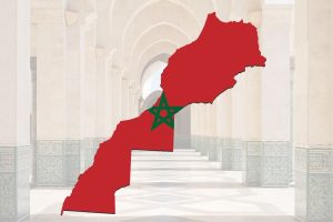
The geography of Morocco is one of the most diverse in Africa and the Mediterranean world. Few countries combine Atlantic and Mediterranean coastlines, towering mountain ranges, fertile plains, vast deserts, and ancient river systems within a single national territory. This geographical diversity has shaped Morocco’s history, culture, economy, climate, and even the way its cities and villages developed over centuries.
So, what are the major geographical features of Morocco?
What makes Morocco’s geography unique compared to its neighbors?
And what little-known geographical facts explain how Moroccans live today?
This in-depth guide answers all of that and more.
Where Is Morocco Located?
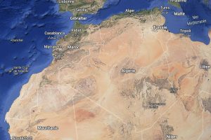
Morocco is located in North Africa, at the crossroads of Africa, Europe, and the Middle East.
-
North: Mediterranean Sea
-
West: Atlantic Ocean
-
East: Algeria
-
South: Mauritania and the Sahara
At its narrowest point, Morocco is separated from Europe by only 14 kilometers (9 miles) at the Strait of Gibraltar. This strategic position made Morocco a historic gateway for trade, migration, and cultural exchange for over 2,000 years.
Major Geographical Features of Morocco
Morocco’s landscape can be divided into five main geographical zones, each with distinct climates, ecosystems, and human activity.
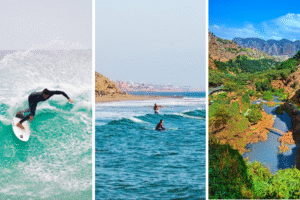
1. The Atlantic and Mediterranean Coastlines
Morocco has one of the longest coastlines in Africa, stretching over 3,500 kilometers.
Atlantic Coast
-
Extends from Tangier to Dakhla
-
Features sandy beaches, fishing ports, and cliffs
-
Influences climate with cool ocean currents
Major coastal cities include Casablanca, Rabat, Essaouira, Agadir, and El Jadida.
The Atlantic coast is crucial for:
-
Fishing industry
-
Trade and ports
-
Tourism and renewable energy (wind farms)
Mediterranean Coast
-
Shorter but more mountainous
-
Includes cities like Tangier, Tetouan, Al Hoceima
-
Warmer waters and smaller beaches
2. The Rif Mountains
Located in northern Morocco, the Rif Mountains run parallel to the Mediterranean coast.
Key Facts
-
Lower elevation than the Atlas Mountains
-
Rugged terrain and deep valleys
-
Home to traditional Amazigh (Berber) communities
This region is known for:
-
Terraced farming
-
Olive cultivation
-
The blue city of Chefchaouen
The Rif Mountains act as a natural barrier between the coast and inland plains.
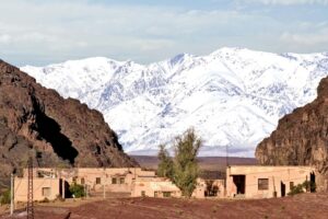
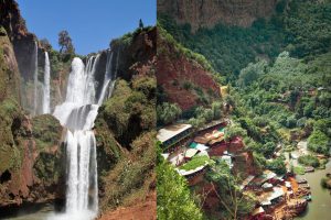
3. The Atlas Mountains: Backbone of Morocco
The Atlas Mountains are the most dominant geographical feature of Morocco and divide the country into climatic and cultural zones.
The Atlas Range Includes:
-
High Atlas – Highest mountains in North Africa
-
Middle Atlas – Forested plateaus and lakes
-
Anti-Atlas – Ancient rocky landscapes near the Sahara
Notable Facts
-
Mount Toubkal (4,167 m / 13,671 ft) is the highest peak in North Africa
-
Snowfall occurs in winter
-
Source of major rivers and water systems
The Atlas Mountains:
-
Separate coastal regions from the Sahara
-
Support agriculture through snowmelt
-
Shape settlement patterns and architecture
4. The Moroccan Plains and Plateaus
Between the mountains and the coast lie fertile plains that form Morocco’s agricultural heartland.
Major Plains
-
Gharb Plain
-
Saïss Plain
-
Tadla Plain
-
Haouz Plain (near Marrakech)
These regions benefit from:
-
Rich soil
-
Moderate rainfall
-
Irrigation from rivers
They support:
-
Wheat and barley
-
Citrus fruits
-
Olives and vegetables
Most of Morocco’s population lives in or near these plains.
5. The Sahara Desert and Pre-Saharan Zones
Southern and southeastern Morocco transitions into the Sahara Desert, one of the world’s most extreme environments.
Key Desert Areas
-
Erg Chebbi (Merzouga dunes)
-
Zagora and M’Hamid
-
Stone deserts (hamadas) and sand seas (ergs)
Despite harsh conditions:
-
Nomadic traditions persist
-
Oases support palm agriculture
-
Ancient caravan routes crossed this region
The Sahara plays a major role in Morocco’s tourism and cultural identity.

Climate and Weather Patterns in Morocco
Morocco’s geography creates multiple climate zones.
Coastal Climate
-
Mild summers
-
Cool winters
-
High humidity
Mountain Climate
-
Cold winters
-
Snowfall in the Atlas
-
Cooler summers
Inland & Desert Climate
-
Hot summers
-
Cold desert nights
-
Low rainfall
This climatic diversity allows Morocco to produce both Mediterranean and desert crops.
Rivers, Water, and Natural Resources
Morocco’s rivers are mostly seasonal but vital.
Major Rivers
-
Sebou River – Longest in Morocco
-
Oum Er-Rbia – Key for agriculture
-
Draa River – Longest river system, mostly dry
Water management is critical due to:
-
Irregular rainfall
-
Climate change
-
Population growth
Morocco has invested heavily in dams and renewable energy to adapt.
Geography of Morocco Facts (That Most People Don’t Know)
-
Morocco is the only African country with both Atlantic and Mediterranean coasts
-
Snow exists in Morocco every winter
-
Morocco has over 10 distinct ecosystems
-
The Atlas Mountains are geologically older than the Alps
-
Morocco sits on a tectonic boundary between Africa and Europe
These geographical facts explain Morocco’s ecological richness and strategic importance.
How Geography Shaped Moroccan History and Culture
Geography influenced:
-
Trade routes across the Sahara
-
Defensive cities in mountains
-
Coastal contact with Europe
-
Nomadic vs. settled lifestyles
Mountain isolation preserved Amazigh languages, while coastal access encouraged global trade.
Geography and Modern Morocco
Today, Morocco’s geography continues to shape:
-
Renewable energy projects (solar in the desert, wind on the coast)
-
Tourism routes (desert, mountains, beaches)
-
Agricultural zoning
-
Urban expansion
Morocco’s development strategy is closely tied to its land.
Conclusion: Why the Geography of Morocco Is So Unique
The geography of Morocco is not just a physical map—it is the foundation of the country’s identity. From snowy mountains and fertile plains to endless deserts and strategic coastlines, Morocco’s land explains its history, diversity, and resilience.
Understanding Morocco’s geography helps travelers, students, and researchers see the country not as a single landscape—but as many worlds in one.